
THE GREAT CATASTROPHE OF RIO GRANDE DO SUL
- LUÍZ GUSTAVO DA COSTA FARINHA
- May 21, 2024
- 3 min read
By: Luíz Gustavo da Costa Farinha

RIO GRANDE DO SUL FLAG.
The beginning:
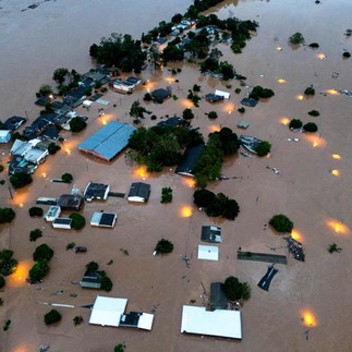
Rio Grande do Sul is experiencing one of its worst climatic tragedies. The rain, which has persisted for at least a week, has put the entire state in a state of calamity and is expected to continue for the next few days, causing more damage. The official death toll is over 100 and hundreds of people are missing amid the floods.
Meteorologists explain that the catastrophe is the result of at least three phenomena affecting the region that have been aggravated by changes in the climate. And the trend is worsening due to the forecast of more rain.
The condition began on April 26, when the National Meteorological Institute (Inmet), linked to the federal government, issued a storm warning for the state. On that day, the forecast was still for rain in some regions of the state. But the damage worsened over the days.
According to experts, the calamity is the result of a number of factors:
There was a cavado, which is an intense wind current, acting over the region, which made the weather unstable;
This was coupled with a corridor of humidity coming from the Amazon, which increased the strength of the rain;
The scenario was aggravated by an atmospheric blockade, a reflection of the heatwave, which made the center of the country dry and hot, leaving the rain concentrated at the extremes.

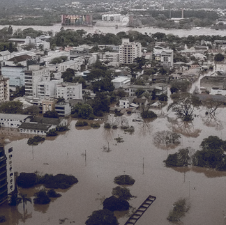
Before and after RS.
Timeline
26/04/2024:
On April 26, 2024, nobody expected much news.
The rains hit Rio Grande do Sul (RS), nothing too extraordinary at the time, but little did they know that the nightmare was to come.
27/04/2024:
On April 27, 2024, the rainy scenario continued in Rio Grande do Sul, heavy rains were beginning to fall and the worst was yet to come.
28/04/2024:
On April 28, 2024, the National Meteorological Institute (INMET) issued an orange alert with a risk of storms for the entire southern part of the state of RS. Accumulated rainfall ranged from 50 to 100 millimeters.
In addition to the precipitation, wind gusts of between 60 and 100 km/h could hit the region, accompanied by hail. There was also a risk of power cuts, falling trees, damage to crops and flooding, according to the alert.
29/04/2024:
On April 29, 2024, the National Meteorological Institute (INMET) issued a red alert with a high risk of accumulated rainfall in RS. There was a high probability of flooding and river overflows, as well as landslides. In addition, the whole of Rio Grande do Sul was under yellow and orange storm alerts, valid until the evening of the 2nd (Thursday).
30/04/2024:
On April 30, 2024, the storms reached:
Municipalities affected: 104;
Deaths: 8;
Injured: 6;
Missing: 21;
People in shelters: 198;
Displaced: 95;
Affected: 3,742.
01/05/2024:
On May 1, 2024, the heavy storms left 10 dead, 21 missing and 11 injured and 4,400 homeless and displaced and the catastrophe was yet to come.
02/05/2024 e 03/05/2024:
On May 2, 2024, the level of the Guaíba rose with an alert in the state of RS. On May 3, 2024, it was already at flood and tragedy level, reaching 4.6 meters, the highest level since the 1941 flood of 4.76 meters.
Currently the state of RS has already been hit with:
Municipalities affected: 437;
Confirmed deaths: 157;
Injured: 806;
Missing: 88;
People in shelters: 76,955;
Displaced: 581,633;
Affected: 2,000,000.
Let's help our nation! Let's help our people! Let's help Rio Grande do Sul!


Comments